Environmental Zoning of Land on the Northern Beaches
The most recent information is at the top of each page.
The Warringah Urban Fringe Association (WUFA) wants all land that is of high environmental value to be zoned an environmental protection zone (E Zone). We share this common view with Warringah Council, the Department of Planning, Minister Hazzard & Minister Goward.
What do we want:
- We do not want any landowner to lose any currently permitted land uses. If any currently permitted land use is to be removed, then compensation is to be paid to the landowner.
- We do not want privately owned land that is of low to moderate environmental value zoned as any Environmetal protection zone (E Zone). Click here to Minister Hazzards Letter stating this instruction. Any privately owned land that is proposed to be zoned an E zone must have an independent report done on it that states it is of high environmental value prior to being zoned an E zone.
- We do not want any privately owned cleared land to be zoned as any Environmental protection zone (E Zone)
Environmental Zoning Review - 29 September 2020 Status:
Northern Beaches Council are carrying out an Environmental Zones review to determine what land is suitable to be an Environmental zone (ie E3 or E4). There is a lot of information that has not been provided to people involved in the Environmental Zoning Review. Below is some very relevent information pertaining to this issue.
- Rural versus Environmental Zoning Comparison
- Department of Planning Practice Note on "Preparing LEPs using the Standard Instrument"
- Department of Planning Practice Note on "Environment Protection Zones"
8 September 2020 Status:
Northern Beaches Council are planning on carrying out an Environmental Zones review to determine what land is suitable to be an Environmental zone (ie E3 or E4). The only problem is they are not following the process outlined by the Minister for Planning or the criteria set out by the Department of Planning.
- Click here to see the letter we have sent to Councillors
- Click here to see the Final recommendations of the Department of Planning into the Environmental zoning in the Northern Councils
- Click here to see the Interim response to the Department of Planning into the Environmental zoning in the Northern Councils
- Click here to see the Frequently Asked Questions to the Department of Planning into the Environmental zoning in the Northern Councils
- Click here to see the media release by Rob Stokes, the Minister for Planning.
- Click here to see the Biodiversity Value map
Meeting with Minister for Planning (Rob Stokes) on 24 June 2015
On 24 June 2015 a representative group of landowners met with Planning Minister Rob Stokes and local member Jonathon O'dea at Parliament house. There were eight representative landowners at the meeting (C3 church, Oxford Falls Grammar School and six other landowners). The meeting was arranged by Brad Hazzard and Jonathon O’Dea.
At the meeting, Minister Stokes issued an instruction to the Department of Planning that whatever permitted land uses we currently have (under LEP2000) are to be included in any new planning proposal for the area. With this the Department of Planning advised that they will relook at the proposed E3 and E4 zonings and readdress them using this criteria. The Department have stated that any proposed environmental zonings will only be carried out with the support of an independent environmental study (They have conceded that WUFA is to be involved with this process).
We still have a long road to travel, but finally we do feel the correct foundations have now been laid. We sense a shift in culture brought on by Minister Stokes to one of ensuring we don’t lose anything and ensuring the owners of land are on board with the process.
Click here to see a letter we have written to the Minister outlining the key points from the meeting
Click here to see the response from the Minister
CORRESPONDENCE WITH MINISTER FOR PLANNING April 2015
Click here to see the letter we have written to Minister Rob Stokes on 19 April 2015
Click here to see the letter that Jonathon O'Dea sent Pru Goward
CORRESPONDENCE WITH the department of Planning APRIL - MAY 2015
Click here to see the letter from Department of Planning 27 March 2015
Click here to see the letter we wrote to the Department of Planning on 19 April 2015
Click here to see the first response to our letter of 19 April 2015 (received 12 May 2015)
Click here to see our response to the first inadequate response from the Department of Planning (sent 17 May 2015)
Click here to see the second response from Department of Planning (dated 18 May 2015)
Click here to see our response to the second inadequate response from Department of Planning (sent 19 May 2015)
Click here to see the Ministerial correspondence referred to in the above email of 19 May 2015
Our Current GIPA Request
We have applied to get a copy of all documents and correspondance from and to Warringah Council over the Strategic Review
Click here for the latest Email regarding the GIPA request
Correspondence with Jonathon O'Dea (State Member for Davidson)
Click here to see the letter we wrote to Jonathon O'Dea (5 February 2015)
Click here to see the letter we received from Jonathon O'Dea (2 April 2015)
Click here to see the letter we wrote to Jonathon O'Dea (24 April 2015)
Click here to see an email received from Jonathon (14 May 2015)
Correspondence with Minister for Planning March 2015
Click here to see the Letter to Minister for Planning 22 March 2015
Click here to see the Talk of the Town results
Click here to see the Letter from Warringah Council to Minister for Planning 17 September 2015 (This letter was obtained through GIPA and has not been publically released)
Media release - 1 March 2015
Click here to see the media release
Warringah Council meeting scheduled for Tuesday 24 February 2015 at 6:00pm (at council chambers)
Item 8.5 of the Council meeting on Tuesday 24 February 2015 is to vote on the zoning of land in the deferred area.
Click here to see the agenda item
Click here to see the Placards for the Council Meeting
Please come along and see what your elected officials decide to do.
Correspondence with Pru Goward, Brad Hazzard & Jonathon O'Dea - February 2015
WUFA has sent the following letters:
Letter to Pru Goward (click here to see it)
Letter to Brad Hazzard (click here to see it)
Letter to Mike Baird (click here to see it)
Letter to Jonathon O'Dea (Click here to see it) Letter from Jonathon Odea to Pru Goward (Click here to see it)
Corresponence between the Department of Planning and Warringah Council - January 2015
A letter was sent by the Department of Planning to Warringah Council on 23 January 2015. Click here to see it.
This letter also contained a proposed zoning map. Click here to see it.
WUFA responded imediately with a letter to the Department of Planning. Click here to see it.
Letter to Pru Goward (Minister for Planning) - November 2014
We wrote to the Minister for Planning. Click here to see the letter.
We have never received a response to this letter.
Submission to the Department of Planning - October 2014
A team of WUFA members met with the management team involved with the strategic review on 28 October 2014. At this meeting we handed over a comprehensive submission. Click here to see the electronic version of it.
What WARRINGAH COUNCIL decided ON TUESDAY 26 AUGUST AT 6:00PM
WARRINGAH COUNCIL ARE DUE TO VOTE ON THE ZONING OF OUR LAND ON TUESDAY 26 AUGUST AT 6:00PM
Council are to vote for one of five options. The options are:
Option 1:
This is Warringah Council's proposal and the option that is recommended by Warringah Council staff
It does not follow the instructions of the Minister for Planning. click here to see the ministers letter.
It does not follow the NSW government’s position that clear criteria and strong evidence is required before zoning an area E3. click here to see the NSW Governments position on this
It does not follow the unanomous recommendation of the Warringah Development Assessment Panel (see information below on this).
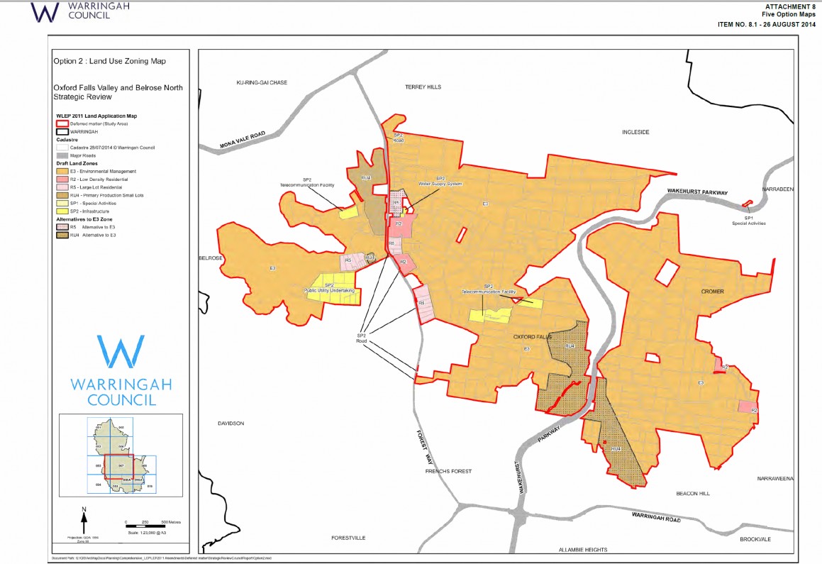
Option 2:
This is a variation on Warringah Council's original proposal
It does not follow the instructions of the Minister for Planning. click here to see the ministers letter.
It does not follow the NSW government’s position was that clear criteria and strong evidence is required before zoning an area E3. click here to see the NSW Governments position on this
It does not follow the unanomous recommendation by the Warringah Development Assessment Panel (see information below on this).
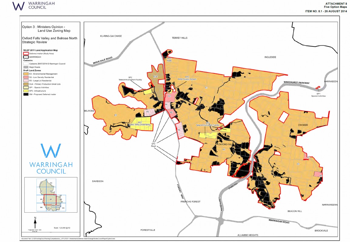
Option 3:
Warringah Council state this is in line with "The Ministers opinion that any land zoned E3 (under Option 1) that contains ‘no-to moderate’ environmental constraint should remain deferred."
Option 3 is not in line with the Minister's instruction as it is only proposing to defer some of the land that is of "No to Moderate Environmental value". See next section below on "What is the the environmental value of the land".
Option 4:
This is WDAP's recommendation that all land remain deferred pending Stage 2 of the Strategic Review.
So after waiting (and being in limbo) for 3 years for a strategic review to be done (which has cost Warringah Council a small fortune), it is OK to stay "wait for another study to be done"?
It is also worth pointing out a statement from the Warringah Council agenda on the analysis of this option states "Council does not have budget to undertake Stage 2 studies in the near future".
Option 5:
This is the option put forward by WUFA. This is the only option that meets the NSW government's position on environmental zones. The advantages of this Option are:
1) It brings all land into the current LEP (LEP2011), thus saving Warringah Council considerable money, by not needing to run two LEP's concurrently.
2) It follows the instructions of the Minister for Planning. click here to see the ministers letter.
3) It follows the NSW government’s position that clear criteria and strong evidence is required before zoning an area E3. click here to see the NSW Governments position on this
It is clear from this website that the Department of Planning will not allow any land that is of low to moderate environmental development constraints to be zoned an Environmental zone. Option 5 is the only option that meets this criteria.
We want Warringah Councillors to vote for Option 5. Click here to see Option 5.
Click here to see the press release we published on 21 August 2014 about the Council meeting.
Click here to see Pru Goward's press release
Click here to see the letter we have written to Council about the Agenda for this Council Meeting
What is the Environmental Value of the land in the OxfORd Falls Belrose North Area?
Warringah Council carried out a Non Urban Lands Study which was submitted to Council in 2000.
So why is Council saying the land is much more valuable that what was determined in the 2000 Warringah Council Non Urban Lands Study? What evidence do they have to backup their claim? We have asked Council for information on this. Click here to see our request to Council for information on this.
Click here to see Council's reply
So we immediately lodged another formal GIPA request and have not received a response yet (as of 22 August 2014). If Council has nothing to hide, or has information that would help the community understand their position on this why would they not just release it?
Public Hearing minutes
Click here to see our response to the minutes
What does Jonathon O'Dea (Member for Davidson) say about things?
Click here to see his most recent letter
Public Hearing on 18 June 2014
Correspondence with warringah council as of 15 June 2014
We have written to Warringah Council seeking clarification of what Option 1 involves (click here to see our letter). On first reading of the report by council to the Warringah Development Asessment Panel (WDAP) we had thought Option 1 deferred the land the Minister for Planning had instructed them to defer (ie land that was of no-to-moderate environmental value). Click here to see the report to WDAP. Warringah Council has reponded to our letter (click here to see the response) and it appears that Option 1 does not intend to defer any land as instructed by the Minister for Planning in his letter (click here to see the ministers letter).
Status as of 27 May 2014:
As part of Stage 1 of the Strategic Review, Warringah Council is holding an independent public hearing and is seeking an opinion from the Warringah Development Assessment Panel (WDAP) as to the most appropriate land use controls (under Warringah Local Environmental Plan 2011 (WLEP2011)) for deferred land in Oxford Falls Valley and Belrose North. The public hearing is being held at 6:00pm at Warringah Council Chambers on Wednesday 18 June 2014.
Brad Hazzard has saved the day by taking the practical approach that land that is of No-to-Moderate environmental value is not zoned an Environmental zone (ie E3). Click here to see Brad Hazzard's letter.
Summary:
WDAP have been presented by Warringah Council with two options to look at:
Option 1:
This Option is really unclear. We now think it involves the zoning of land as recomended by the draft review (click here to see the map which shows the zonings proposed by the draft Strategic Review). It appears that this option does not folloow the Minister for Planning's instruction to defer all land that is of no-to-moderate environmental value (click here to see a map of the environmental classifications - it is a big file and will take a while to load).
Option 2:
This option has had no consultation with the public or WUFA. This has been put forward by Warringah Council as a compromise so that all land would be rezoned into the new LEP. This compromise zones some land in Oxford Falls Valley as RU4 (as requested by WUFA). This is good for those residents of Oxford Falls Valley, but leaves several properties that option 1 would not have zoned as E3, to be zoned as E3. These residents (and therefore WUFA) don't want to be E3. The losers in this option are the residents of Cromer, Red Hill, Morgan Rd, Oxford Falls Rd and Kelly's Way who own land that is of no or moderate environmental value. Even though their land is of no or moderate environmental value, they would be zoned as E3 under this option. Click here to see the map of Option 2.
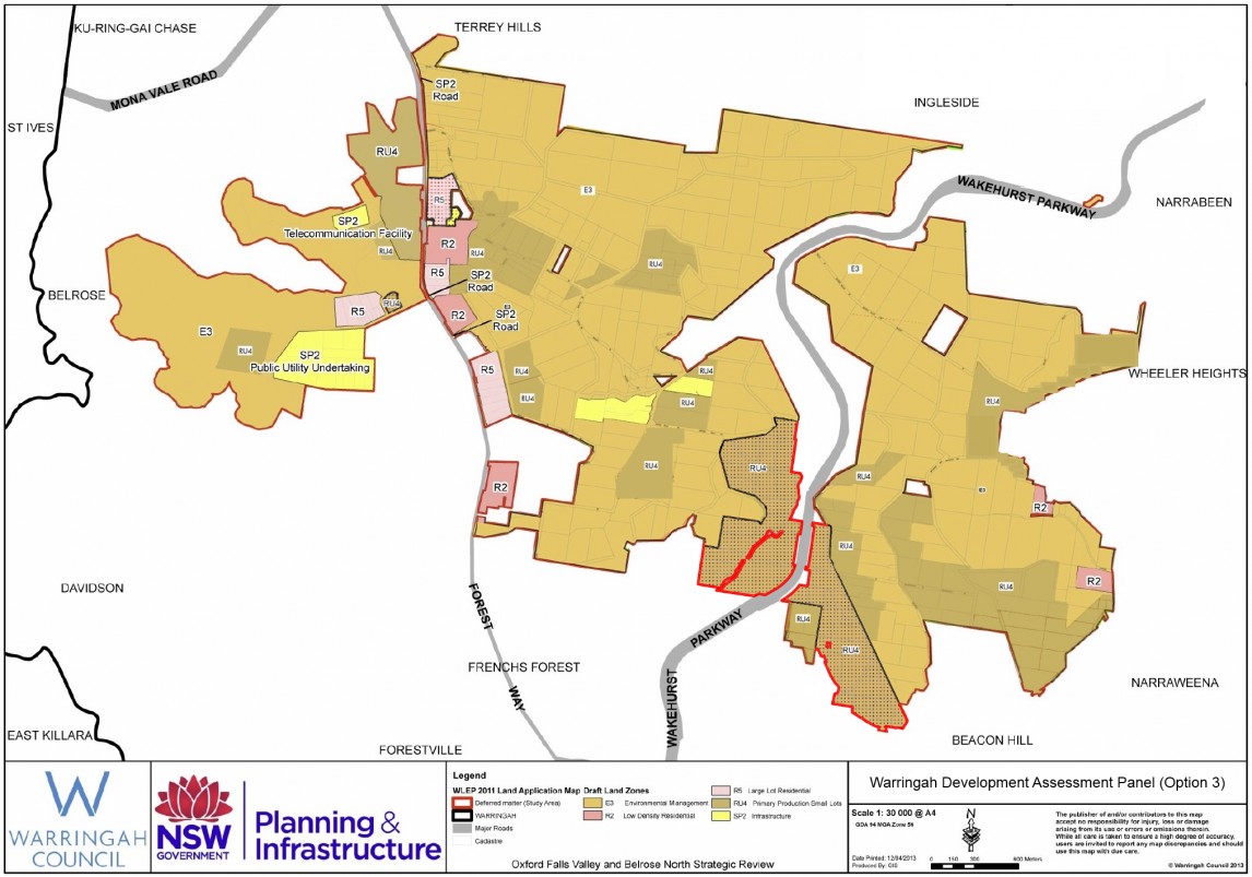
Option 3:
There is currently no Option 3, but WUFA has sent a letter to the WDAP requesting that they consider an option 3 that would be to zone the areas as shown on the map supplied by WUFA. This map is in line with the Ministers letter, with the change being that the land the Minister proposed remain deferred would be zoned RU4 (Primary Production Small Lots). Click here to see the letter to WDAP. Click here to see the map of Option 3.
We encourage you to attend this Public Enquiry and have your say. Ring the Panel Coordinator on 9942 2313 if you wish to address the WDAP Panel.
Below is the Final Strategic Review Information RELEASED IN MAY 2014 (Click on the name to open the file):
Letter from the Minister for Planning
Final Submissions Report A- Appendix A
Final Submission Report (Submissions)- Appendix B (Part 1)
Final Submission Report (Submissions)- Appendix B (Part 2)
The Department of Planning and Warringah Council exhibited the draft Oxford Falls & Belrose North StrAtegic Review from 22 June 2013 to 7 August 2013. Below are the various files that form the draft review as published by the Department of Planning (Click on the Name to Open the file):
Draft Oxford Falls & Belrose North Strategic Review
Map 4 - Cumulative Level of Environmental Constraint
Map 5 - Outcome of the Primary Environmental Constraint Analysis
Map 6 - Outcome of the Secondary Environmental Constraint Analysis
Map 8 - Additional permitted uses
Below is further information provided on the dept of planning website after WUFA lodged a GIPA (ie Freedom of Information) request - Click on the Name to open the file:
Acid Sulfate Soils Constraints Land Map
Core Habitat Constraints Land Map
Flood Planning Level Constraints Map
Proximity to Public Transport Infrastructure
Significant Vegitation Constraints Map
Threatened Species Habitat Constraints Land Map
Wetland Buffers Constraints Land Map
Secondary Constraints Analysis table (This cross references site ID's with addresses)
BELOW IS FURTHER INFORMATION PROVIDED TO WUFA UNDER GIPA (IE FREEDOM OF INFORMATION) - CLICK ON THE NAME TO OPEN THE FILE:
/_files/GIPA/Project_Control_Group_copy.pdf
/_files/GIPA/Secondary_Constraints_Analysis_Record_Table_-__Any_Constraints.pdf
/_files/GIPA/Secondary_Constraints_Analysis_Record_Table_-__Any_Constraints.pdf
/_files/GIPA/Significant_Environmental_Constraint.pdf
/_files/GIPA/Significant_Environmental_Constraint___AnyConstraint.pdf
/_files/GIPA/Warringah_AnyConstraints_Rating_2.pdf
/_files/GIPA/Warringah_AnyConstraints_Rating_2_01.pdf
/_files/GIPA/Warringah_Hazards_Constraints.pdf
/_files/GIPA/Warringah_Secondary_Constraints_Bushfire.pdf
/_files/GIPA/Warringah_Secondary_Constraints_Bushfire2.pdf
/_files/GIPA/Warringah_Secondary_Constraints_Busstop_buffer.pdf
/_files/GIPA/Warringah_Secondary_Constraints_Composite_Centres.pdf
/_files/GIPA/Warringah_Secondary_Constraints_Composite_Centres_buffer.pdf
/_files/GIPA/Warringah_Secondary_Constraints_Stormwater.pdf
/_files/GIPA/Warringah_Secondary_Constraints_Stormwater2.pdf
/_files/GIPA/Warringah_Secondary_Constraints_Telecom.pdf
/_files/GIPA/Warringah_Secondary_Constraints_Telecom_buffer500.pdf
/_files/GIPA/Warringah_Species_Constraints.pdf
/_files/GIPA/Warringah_Species_Constraints_with_revised_wildlife_cor.pdf
/_files/GIPA/Warringah_Watermain_Centreline.pdf
Completed Site Analysis forms (provided under GIPA):
/_files/GIPA/r_SI_Forms_Part1.pdf
/_files/GIPA/r_SI_Forms_Part2.pdf
/_files/GIPA/r_SI_Forms_Part3.pdf
/_files/GIPA/r_SI_Forms_Part4.pdf
/_files/GIPA/r_SI_Forms_Part5.pdf
/_files/GIPA/r_SI_Forms_Part6.pdf
/_files/GIPA/r_SI_Forms_Part7.pdf
/_files/GIPA/r_SI_Forms_Part8.pdf
/_files/GIPA/r_SI_Forms_Part9.pdf
Minister Brad Hazzard has been a great help with the proposed E3 zoning so far:
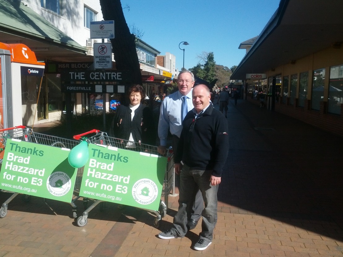
Brad Hazzard at Forestville Shopping Centre meeting with Bev Harris (long term resident) and John Holman (President of WUFA)